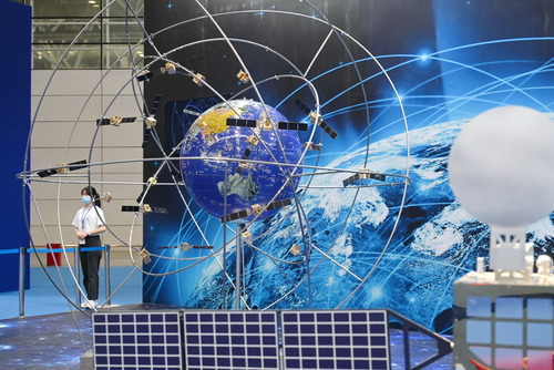
CHENGDU, Nov. 25 (Xinhua) -- Aided by the millimeter-level high-precision technology of China's BeiDou Navigation Satellite System (BDS), a geological disaster monitoring and early warning system can help minimize human life and property losses when landslides occur.
This is just one among a host of BDS applications that were on display at the 11th China Satellite Navigation Conference held in southwest China's Chengdu City this week.
The conference was the first significant event for exchanges on satellite navigation hosted by China following the commissioning of the BDS-3 system on July 31, 2020. The BDS-3 system is the first space infrastructure the country has provided for global public service.
At the conference, over 100 enterprises showcased products and services based on the BDS, covering a wide range of areas including surveying and mapping, navigation, 5G, the Internet of Things, autonomous driving, and disaster reduction and relief.
"While injecting impetus into traditional industries, the BDS is also accelerating its synergy with new technologies such as blockchain, the Internet of Things and artificial intelligence, bringing about profound innovation and transformation," said Ran Chengqi, director of the China Satellite Navigation Office, who estimated that the BDS-related industry will grow to be a trillion-yuan-level market in the future.
According to a report released by the office at the conference, the total output value of China's satellite navigation and location services industry has increased by more than 20 percent annually for the past 10 years, hitting 345 billion yuan (52.5 billion U.S. dollars) in 2019. It is expected to exceed 400 billion yuan this year.
The applications of the BDS in emerging industries such as unmanned aerial vehicles (UAVs), outdoor robots and autonomous driving may bring exponential growth to the BDS-related industry, said Zhou Ruxin, chairman of Beijing BDStar Navigation Co., Ltd.
On Monday, Beijing-based Unicore Communications, Inc. released a new-generation high-precision positioning chip that supports BDS-3 and can meet the needs of high-end applications such as autonomous driving and UAVs. It is considered the most advanced positioning chip China has developed to date and is among the most advanced worldwide.
BDS technologies have already been used in some Wing Loong models -- China-developed UAVs. "UAVs are products that rely heavily on the support of external systems such as the BDS to fully function," said chief Wing Loong designer Li Yidong, who envisions greater application scenarios for BDS-assisted Wing Loong UAVs.
Yang Changfeng, chief designer of the BDS, said the navigation satellite system both underpins economic foundations and boosts emerging technologies.
"Never before has the BDS penetrated every corner of life and every social scenario as it does today," said Yang, comparing it to vital elements such as water and air.
BDS-related products have so far been exported to more than 120 countries and regions. BDS-based solutions for land ownership confirmation, precision agriculture, digital construction, vehicle and ship oversight, and smart ports have been successfully applied in various regions of Asia, Europe and Africa.
The BDS is one of four global navigation satellite systems worldwide, alongside the United States' GPS, the European Union's Galileo, and Russia's GLONASS.
China has been actively encouraging cooperation and exchanges between the BDS system and other navigation systems. The BDS and GLONASS are compatible, and the BDS and GPS are compatible and interoperable. Enditem


 A single purchase


