


SHENYANG, Sept. 12 (Xinhua) -- A scenic coastal highway in China has left a deep impression on Lee Jae-jae, a cycling enthusiast from the Republic of Korea (ROK).
Lee was among a group of 49 cyclists that visited Dandong, a border city in northeast China's Liaoning Province, aboard a passenger-and-cargo ferry from Incheon, ROK.

A tourist takes photos of migratory birds at a migratory bird habitat on the Yalu River estuary in Dandong, northeast China's Liaoning Province, April 2, 2026. (Xinhua/Li Gang)
"Dandong has a very comfortable climate and beautiful roadside scenery. The cycling paths, rest areas and other facilities are well-equipped, making for a smooth and pleasant riding experience," he said.
The Dandong section of the G228 national highway offers just a glimpse of the many attractions along the emerging "golden outer ring." China plans to fully link three national highways -- the G219, G331 and G228 -- creating an ultra-long ring route that traces China's borders and coastal areas during the 15th Five-Year Plan period (2026-2030).
Stretching over 26,000 kilometers if connected, nearly two-thirds of the equatorial circumference, the route traverses a diverse tapestry of landscapes and tourist attractions, from coastlines and snow-capped mountains to glaciers, grasslands, deserts, lakes and border crossings. It is poised to become a major corridor driving tourism and broader industrial development.

A tourist poses for a photo in front of a road sign of G331 national highway in northeast China, Oct. 12, 2025. (Xinhua/Wu Qinghao)
Dandong, where the G331 and G228 begin, is already reaping considerable benefits from its location. "Two national highways pass through our village, attracting a constant flow of self-driving travelers and border-tourism lovers throughout the year," said Wang Chunhai, Party chief of Hushan Village of Dandong.
Leveraging this advantage, the village transformed its idle land into recreational vehicle (RV) campsites and homestays, drawing praise from visitors while generating additional collective income for the village, according to Wang.
"Many visitors have told me that the drive from Dandong along the Yalu River offers beautiful scenery the whole way," said Zheng Jinhua, a resident of Guoyuan Village in adjacent Jilin Province, adding that a growing number of villagers have opened homestays or started to sell local farm produce to visitors.

An aerial drone photo taken on Sept. 27, 2025 shows the scenery along the G331 national highway in Erdaobaihe Township of Antu County, northeast China's Jilin Province. (Xinhua/Zhang Nan)
Statistics show that the G331, which traces the country's northern border, welcomed more than 2 million tourists in the first half of this year. For residents of border villages along the route, tourism has become a source of livelihood at their doorstep, with many investing in homestays, running specialty restaurants or selling local agricultural products.
Serving as a principal artery along China's western and southern frontier, G219 is home to a remarkable diversity of ecological and geographical landscapes, winding through the Taklamakan Desert, China's largest, and the Qinghai-Tibet Plateau, widely known as the "roof of the world."
In June, the China Tourist Attractions Association, joined by state-owned cultural and tourism groups from Xinjiang, Xizang, Yunnan and other provincial-level regions, initiated preparations for a coordinated development mechanism for the G219 cultural and tourism industry, with the goal of better aligning cultural and tourism resources along the route.
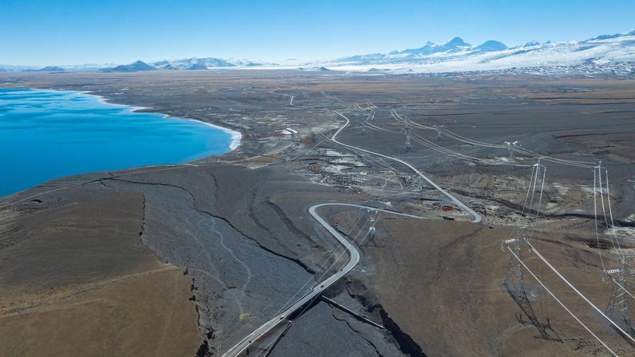
An aerial drone photo taken on Jan. 3, 2026 shows the National Highway 219 (coded G219) near Baiku Lake in Xigaze, southwest China's Xizang Autonomous Region. (Xinhua/Tenzin Nyida)
"As China's longest border road, G219 boasts abundant cultural and tourism resources along the way, such as snow-capped mountains, glaciers and grasslands, which can directly fuel tourism, rural revitalization and border stability and prosperity," said Liu Rangqun, general manager of Xinjiang Culture & Tourism Investment Group Co., Ltd.
Meanwhile, the G228, which stretches along China's eastern coastline, links coastal ports and forms a transportation and logistics channel connecting land borders to coastal ports, noted Li Hongchang, a professor at Beijing Jiaotong University.
"By organically integrating transportation hubs, it helps drive the all-round economic and social development of the areas it passes through," Li said.
Along the route in Dandong, for example, cross-border e-commerce transaction volume posted a double-digit increase over the past year.
A well-developed road network can transform what was once a transportation periphery into a frontier for openness, said Ma Jiangbo, deputy director of the China economic research center under the China Institute for Innovation & Development Strategy.
An integrated network, rather than three separate channels, can further reduce cross-border logistics costs and make China's industrial layout more balanced, Ma added.
During the 15th Five-Year Plan period, the country has planned to work faster to boost its strength in transportation and improve the modern integrated transportation system, raising the completion rate of the main framework of the national integrated multidimensional transportation network to 95 percent.
 A single purchase